 |
|
|
RISING FROM THE DEPTHS OF THE SEA
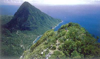
It must have been a sight to behold: the awesome power of two tectonic plates - crusts of solid material floating on top of the fiery hot, fluid inner centre of our planet earth - grinding into each other until one is forced downwards where it ripples and melts, and the other pushed up until land raises above the waters of the ocean. Thus, St. Lucia was born: as the result of the Atlantic tectonic plate ducking underneath the Caribbean plate, pushing up and laying dry the extreme north and south, areas we now know as Cap Estate (Pointe du Cap) and Moule-a-Chique. The island of St. Lucia first rose from the ocean about fifty million years ago, which makes it relatively young in geological terms. Around the same time, several other islands in the outer arc of the Lesser Antilles emerged also: Anguilla, St. Martin, St Barts, Barbuda, Antigua, the eastern wing of Guadeloupe, Mariegalante, the southern tip of Martinique, the Grenadines, and the southern tip of Grenada. It took several millions of years and four consecutive phases of geological formation to reach the state in which we now recognise the Windward island of St Lucia. After Pointe du Cap and Moule-a-Chique were formed in the Early Tertiary period (50 to 58 million years ago), a second formative stage took place during the Middle Tertiary period (Miocene to Pliocene, 30 to 40 million years ago). This period was, if possible, even more spectacular than the first. Rock from the Atlantic tectonic crust and other scraped-off material that had been forced under the Caribbean plate caused pressure to build up inside the hot earth. For thousands of years, this red-hot fluid rock (magma) accumulated, waiting for a release.Then one day, the continuously grinding movement caused earthquakes and the crust of the earth broke open. In a series of violent volcanic explosions, masses of flammable gas, ashes, rocks and boulders rushed upwards and out into the open sea and air, creating the central, northern and eastern parts of St Lucia. When the smoke subsided and dust had settled, an island consisting of dozens of high, sharp-edged mountains separated by deep chasms showed itself to the world. Millions of years later, with the effects of rain, wind and gravity blunting the jagged peaks and ravines, these mountains took on softer, more rounded shapes. Rocks and boulders slid down hillsides and filled up the abysses between mountain peaks, creating slopes and valleys. Rainwater streaming down the mountain sides collected in creeks, carrying down sand and rocks and depositing them as sediment at the foot of mountains. This is how the wide, expansive, fertile alluvial valleys near the coast came into being: Roseau, Cul-de-Sac, Mabouya/Fond D'Or, Marquis and Troumassee. Erosion also wore down the central divide that runs from the south-west to the north-east across the spine of St Lucia - the Barre de L'Isle - until today it reaches just 900 feet (274 meters) above sea level. What high peaks still remain in northern and central St Lucia are the surviving cones (or pitons) of La Sorciere (2,221ft/677m), Piton Flore (1,850ft/564m), Mount Lacombe (1,485ft/453m) and Piton St. Esprit (1,919 ft/585m). Pitons come into being during the last stages of volcanic activity, when the volcano's 'nozzle' stops ejecting and the last magma hardens inside of it. This crystallized magma is hard like basalt and hence erodes more slowly than the rocky mountainsides that surround it. And still St Lucia had not reached the shape we know her by today. Around 26 million years ago (late Tertiary, late Pliocene) a third formative stage - again volcanic in nature - shook up the islands of the Lesser Antilles. Once again, St Lucia changed shape dramatically. A long series of eruptions (taking place over several thousands of years) created the mountainous areas south of Roseau, extending into the centre of the island along the Anse La Raye River and from there south to Mount Gimie and west to Gros Piton. The dramatic western coastline and central mountainscapes for which St Lucia has gained such fame at home and overseas were created during this third geological stage. For such a small island (just 20 by 40 kilometers) its mountains attain respectable heights: Mount Gimie (3,117 ft/950m), Piton Canarie (3,012 ft/918m), Mount Paix Bouche (2,445 ft/745m), Mount Tabac (2,224 ft/678m), Mount Parasol (2,010 ft/613 m), Mount Houelmon (2,094ft/638m), Mount Grand Magazin (2,117 ft/645m) and the two most famous ones of all: Petit Piton (738m) and Gros Piton (786 m) - both of which rise directly up out of the Caribbean sea. Having had less time to erode, these mountains are all still sharper, with more jagged edges and ridges than those of central, northern and eastern St Lucia. In the Soufriere area, a circular depression about six kilometers in diameter has been discovered, indicating the presence of an enormous defunct, collapsed crater (caldera). Scientists believe that when the crater collapsed, its floor dropped some 250 meters to form the large, bowl-like impression in the landscape now known as the Qualibou Caldera. On this crater floor, a series of thirty-three very violent volcanic explosions subsequently took place, throwing up glowing avalanches of gas and ashes and ejecting rocks and boulders with such force that some landed as far as thirteen kilometers away from the crater. These are, with good reason, described as 'volcanic bombs'. Up to today, six domes and seven volcanic craters remain on the Qualibou Caldera floor, in the area known as Belfond. Around the same time, the domes of Gros Piton, Petit Piton, Plaisance and Rabot were formed also. Erosion eventually caused the skirts of sediments around these mountains to roll down and wash away, leaving just the pinnacle-shaped pitons or cores behind. Neither Rome nor Soufriere was created in one day: these volcanic explosions took thousands of years, and in between eruptions, there were long periods of torrential rain and flooding. These floodwaters in turn washed down the mountains, causing mudflows (glacis). These mudflows could be absolutely massive: there is evidence near Soufriere of one mudflow which left behind a layer of sediment over forty meters (132 ft) deep. An even bigger mudflow, caused by the mother of all volcanic eruptions in Soufriere at some stage during the Holocene era (Quaternary), covered the entire area between Soufriere and Vieux Fort. This was the fourth and (so far) last geologically formative period in the island's existence. Just think of how peanut candy (prasline) is made, with melted sugar being poured in a baking tray full of nuts, and you can imagine how this huge, fan-shaped flow of mud filled up ravines, inundated hills and skirted mountains. Where once the south of St Lucia was as mountainous as the north, it now consists of neat slopes and rolling hills. Around Vieux Fort, it created the ten square kilometers of perfectly level land which now accommodate the Hewanorra International Airport. Interesting also is that in Vieux Fort, the oldest stage of geological formation thus lies shoulder-to-shoulder with the newest one: the cape of Moule-a-Chique, created by tectonic uplift, rising protectively over the mudflowed plains of Vieux Fort. Over time, the earth in St Lucia calmed down to the extent that today, the only signs of active volcanism are a sulfurous steam and water vent just south of the village of Soufriere. Here, the constant release of heat and gas through cracks in the earth's crust has gained fame for being the world's only 'drive-in' volcano, thanks to the collapse of the caldera floor. It also makes for relative safety, in the sense that pressure under the earth's crust is constantly being released. The last time the Soufriere volcano in St Lucia rumbled was in 1780. Volcanoes in the Lesser Antilles arc that remain active today are those in Montserrat (erupting again since the mid-1990s), St Vincent (last exploded in 1979), Martinique (where in 1902, flammable gas eruptions from Mont Pélé killed some thirty-thousand people!), Dominica, Guadeloupe and St Kitts. Off the north coast of Grenada, underwater volcano Kick 'em Jenny continues to stir also. Although the volcanoes of the Lesser Antilles are all joined underground, the eruptions in Montserrat have had little effect in St Lucia, other than to somewhat increase the power of the steam and water vents at the Soufriere Sulphur Springs. Jolien Harmsen holds a PhD in Caribbean Social History. The above article is an adapted version of the first chapter of her General History of St Lucia (MacMillan Caribbean, forthcoming). Dr Harmsen is also the author of Sugar, Slavery and Settlement. A Social History of Vieux Fort, St Lucia (St Lucia National Trust, 1999) and Rum, Roti, Onrecht, a novel set in a fictitious Caribbean Island (Luitingh-Sijthoff, Amsterdam, 2003). |
|
|
|
||||||||||||||||||||
|
© 2001-2004 Island Visions Ltd. |